Geolocate

Panchkula topographic map

Click on the map to display elevation.

About this map

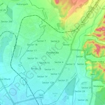
Name: Panchkula topographic map, elevation, terrain.

Location: Panchkula, Haryana, 134109, India (30.65754 76.81511 30.73754 76.89511)

Average elevation: 347 m

Minimum elevation: 307 m

Maximum elevation: 483 m

Other topographic maps

Click on a map to view its topography, its elevation and its terrain.

Sector 24

India > Haryana > Panchkula

Average elevation: 327 m

Sector 3

India > Haryana > Panchkula

Average elevation: 341 m

Gear up for your next adventure:

🔭Compact Monocular - One-handed bird watching and trail spotting
🧣Merino Neck Gaiter - Protects against wind, sun, and cold at high altitudes
🛰️Satellite Messenger - Emergency communication for areas with no cell service
🧤Thermal Hiking Gloves - Grip-enhanced gloves for cold-weather altitude trekking
🪑Ultralight Camping Stool - Compact seating for rest stops during long hikes

As an Amazon Associate, this site earns from qualifying purchases at no extra cost to you.