Geolocate

Massafra topographic map

Click on the map to display elevation.

About this map

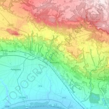
Name: Massafra topographic map, elevation, terrain.

Location: Massafra, Taranto, Apulia, 74016, Italy (40.51621 17.05136 40.68586 17.18569)

Average elevation: 187 m

Minimum elevation: -2 m

Maximum elevation: 516 m

Other topographic maps

Click on a map to view its topography, its elevation and its terrain.

Marinara

Italy > Apulia > Taranto > Mottola

Average elevation: 261 m

Saturo

Italy > Apulia > Taranto > Leporano

Average elevation: 12 m

Gear up for your next adventure:

Backpacking Tent - Lightweight tent for long-distance hiking trips
🧥Ultralight Puffy Jacket - Maximum warmth that packs down to the size of an orange
🥾Waterproof Hiking Shoes - Durable shoes for wet and rugged trails
🥾Waterproof Hiking Boots - Essential footwear for rugged terrain and wet Canadian trails
🕯️Camping Lantern - Illuminates your entire campsite with high-efficiency LEDs

As an Amazon Associate, this site earns from qualifying purchases at no extra cost to you.