Geolocate

Naslo topographic map

Click on the map to display elevation.

About this map

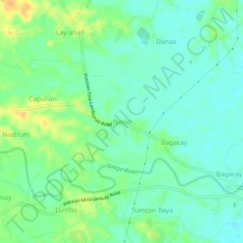
Name: Naslo topographic map, elevation, terrain.

Location: Naslo, Iloilo, Western Visayas, 5008, Philippines (10.93545 122.59034 10.97545 122.63034)

Average elevation: 31 m

Minimum elevation: 20 m

Maximum elevation: 51 m

Other topographic maps

Click on a map to view its topography, its elevation and its terrain.

Balasan

Philippines > Iloilo

Average elevation: 42 m

Banate

Philippines > Iloilo

Average elevation: 34 m

Miagao

Philippines > Iloilo

Average elevation: 97 m

Lambunao

Philippines > Iloilo > Lambunao

Average elevation: 127 m

Anilao

Philippines > Iloilo > Anilao

Average elevation: 52 m

Bayas Island

Philippines > Iloilo > Estancia > Bayas

Average elevation: 1 m

Balbagon Island

Philippines > Iloilo > Carles

Average elevation: 0 m

Leganes

Philippines > Iloilo

Average elevation: 8 m

Gear up for your next adventure:

🦯Trekking Poles - Reduced impact on joints for steep topographic climbs
🔨Vehicle Emergency Tool - Safety tool for remote road trips to trailheads
Camping Groundsheet - Protect your tent from moisture and dirt
🥾Approach Boots - Comfortable boots for hiking and climbing approaches
🧢Sun Protection Cap - Breathable cap to protect from sun exposure

As an Amazon Associate, this site earns from qualifying purchases at no extra cost to you.