Geolocate

Anilao topographic map

Click on the map to display elevation.

About this map

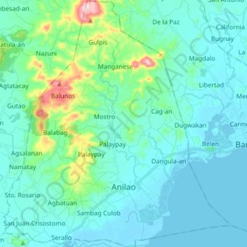
Name: Anilao topographic map, elevation, terrain.

Location: Anilao, Iloilo, Western Visayas, 5009, Philippines (10.94706 122.68641 11.07737 122.80881)

Average elevation: 52 m

Minimum elevation: -1 m

Maximum elevation: 354 m

Other topographic maps

Click on a map to view its topography, its elevation and its terrain.

Sta. Rita

Philippines > Iloilo > Anilao

Average elevation: 8 m

Gear up for your next adventure:

🛶Canoe Life Vest - Safety vest for water sports
👖Convertible Hiking Pants - Zip-off legs to adapt to changing weather conditions
🛶Waterproof Dry Bags - Keep electronics and clothes dry during river crossings
🏃Hydration Running Vest - Carry water and maps close to your body for speed
🥫Freeze-Dried Meals - Lightweight, high-calorie nutrition for multi-day treks

As an Amazon Associate, this site earns from qualifying purchases at no extra cost to you.