
Make a donation
Gear up for your next adventure:
As an Amazon Associate, this site earns from qualifying purchases at no extra cost to you.
Bünde topographic map
Click on the map to display elevation.
Make a donation
Gear up for your next adventure:
As an Amazon Associate, this site earns from qualifying purchases at no extra cost to you.
Bünde
Das Stadtwappen (zwei sich die Hand reichende Ritter) spielt auf die Sachsen Hengist und Horsa an, die der Sage nach im 5. Jahrhundert an dieser Stelle einen Bund zur Eroberung Englands schlossen. Tatsächlich lebte zu dieser Zeit im Bünder Land der Sachsenstamm der Engern. Dennoch ist es eher unwahrscheinlich, dass der Name der Stadt auf dieses Bündnis zurückzuführen ist. Vielmehr weist der Name Bünde vermutlich auf eine Anhöhe hin, die früher Buhn (wortverwandt mit Bühne) genannt wurde, woraus sich bis 1222 der Name Bünde entwickelte. Auch heute noch ist die im Vergleich zur Elseniederung erhöhte Lage des alten Stadtkerns um die Laurentiuskirche deutlich erkennbar.
Make a donation
Gear up for your next adventure:
As an Amazon Associate, this site earns from qualifying purchases at no extra cost to you.
About this map
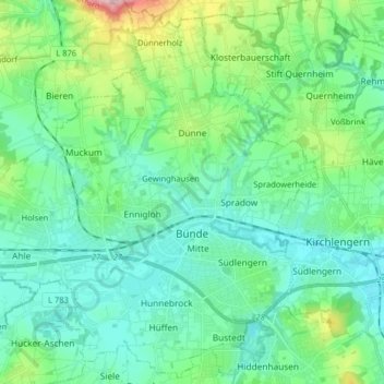
Name: Bünde topographic map, elevation, terrain.
Location: Bünde, Kreis Herford, Nordrhein-Westfalen, 32257, Deutschland (52.16334 8.47507 52.25869 8.63578)
Average elevation: 93 m
Minimum elevation: 53 m
Maximum elevation: 242 m
Make a donation
Gear up for your next adventure:
As an Amazon Associate, this site earns from qualifying purchases at no extra cost to you.
Other topographic maps
Click on a map to view its topography, its elevation and its terrain.
Oetinghauser Heide
Deutschland > Nordrhein-Westfalen > Kreis Herford > Hiddenhausen
Average elevation: 99 m
Make a donation
Gear up for your next adventure:
As an Amazon Associate, this site earns from qualifying purchases at no extra cost to you.
Make a donation
Gear up for your next adventure:
As an Amazon Associate, this site earns from qualifying purchases at no extra cost to you.
Wasserschloss Ulenburg
Deutschland > Nordrhein-Westfalen > Kreis Herford > Löhne > Westscheid
Average elevation: 73 m
Stuckenberg
Deutschland > Nordrhein-Westfalen > Kreis Herford > Herford
Der Hansaweg verläuft über den Höhenzug des Stuckenberges.
Average elevation: 142 m
Mahnen
Deutschland > Nordrhein-Westfalen > Kreis Herford > Löhne > Bischofshagen
Average elevation: 83 m
Make a donation
Gear up for your next adventure:
As an Amazon Associate, this site earns from qualifying purchases at no extra cost to you.
Make a donation
Gear up for your next adventure:
As an Amazon Associate, this site earns from qualifying purchases at no extra cost to you.