
Make a donation
Gear up for your next adventure:
As an Amazon Associate, this site earns from qualifying purchases at no extra cost to you.
Pitt Island topographic map
Click on the map to display elevation.
Make a donation
Gear up for your next adventure:
As an Amazon Associate, this site earns from qualifying purchases at no extra cost to you.
About this map
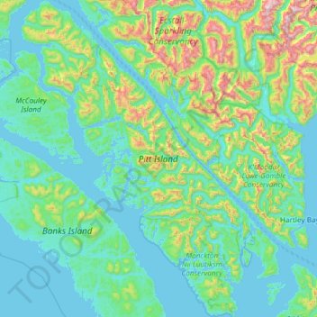
Name: Pitt Island topographic map, elevation, terrain.
Average elevation: 228 m
Minimum elevation: -1 m
Maximum elevation: 1,696 m
North Coast Regional District trails, hiking, mountain biking, running and outdoor activities
Make a donation
Gear up for your next adventure:
As an Amazon Associate, this site earns from qualifying purchases at no extra cost to you.
Other topographic maps
Click on a map to view its topography, its elevation and its terrain.
Skeena
Canada > British Columbia > North Coast Regional District > Area A (North Skeena)
Average elevation: 61 m
Lax Kw'alaams
Canada > British Columbia > North Coast Regional District > Area A (North Skeena)
Average elevation: 63 m
Taaw Tldáaw
Canada > British Columbia > North Coast Regional District > Area D (Graham Island)
Average elevation: 8 m
Kitkatla
Canada > British Columbia > North Coast Regional District > Area C (South Skeena)
Average elevation: 14 m
Make a donation
Gear up for your next adventure:
As an Amazon Associate, this site earns from qualifying purchases at no extra cost to you.
Mount McGrath
Canada > British Columbia > North Coast Regional District > Area C (South Skeena)
Average elevation: 394 m
Watson Island
Canada > British Columbia > North Coast Regional District > Prince Rupert > Watson Island
Average elevation: 104 m
Jalun Lake
Canada > British Columbia > North Coast Regional District > Area D (Graham Island)
Average elevation: 207 m
Alford Point
Canada > British Columbia > North Coast Regional District > Area E (Moresby Island)
Average elevation: 61 m
Make a donation
Gear up for your next adventure:
As an Amazon Associate, this site earns from qualifying purchases at no extra cost to you.
Sandspit
Canada > British Columbia > North Coast Regional District > Area E (Moresby Island)
Average elevation: 13 m
Ship Island
Canada > British Columbia > North Coast Regional District > Area D (Graham Island)
Average elevation: 4 m
Coast Mountains
Canada > British Columbia > North Coast Regional District > Area A (North Skeena)
Average elevation: 334 m
Cape Edensaw
Canada > British Columbia > North Coast Regional District > Area D (Graham Island)
Average elevation: 3 m
Make a donation
Gear up for your next adventure:
As an Amazon Associate, this site earns from qualifying purchases at no extra cost to you.
Sandspit
Canada > British Columbia > North Coast Regional District > Area E (Moresby Island)
Average elevation: 13 m
Client Reefs
Canada > British Columbia > North Coast Regional District > Area C (South Skeena)
Average elevation: 0 m