
Sandspit topographic map
Click on the map to display elevation.
About this map
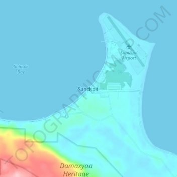
Name: Sandspit topographic map, elevation, terrain.
Average elevation: 13 m
Minimum elevation: -1 m
Maximum elevation: 149 m
Other topographic maps
Click on a map to view its topography, its elevation and its terrain.
Louise Island
Canada > British Columbia > North Coast Regional District > Area E (Moresby Island)
Average elevation: 183 m
Lyell Island
Canada > British Columbia > North Coast Regional District > Area E (Moresby Island)
Average elevation: 92 m
Kunghit Island
Canada > British Columbia > North Coast Regional District > Area E (Moresby Island)
Average elevation: 38 m
Burnaby Island
Canada > British Columbia > North Coast Regional District > Area E (Moresby Island)
Average elevation: 89 m
Louise Island
Canada > British Columbia > North Coast Regional District > Area E (Moresby Island)
Average elevation: 183 m