Geolocate

Gary topographic map

Click on the map to display elevation.

About this map

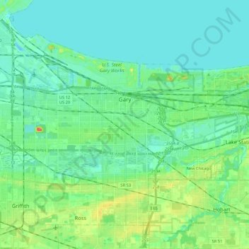
Name: Gary topographic map, elevation, terrain.

Location: Gary, Calumet Township, Lake County, Indiana, United States (41.52197 -87.43311 41.65006 -87.22205)

Average elevation: 185 m

Minimum elevation: 173 m

Maximum elevation: 224 m

Other topographic maps

Click on a map to view its topography, its elevation and its terrain.

Cook

United States > Indiana > Lake County > Cedar Lake

Average elevation: 222 m

Liverpool

United States > Indiana > Lake County > Lake Station

Average elevation: 191 m

Illinoi

United States > Indiana > Lake County

Average elevation: 192 m

Triangle Parkway

United States > Indiana > Lake County > Hammond

Average elevation: 184 m

Lake Seven

United States > Indiana > Lake County > Crown Point

Average elevation: 220 m

Glen Park

United States > Indiana > Lake County > Gary

Average elevation: 193 m

Miller

United States > Indiana > Lake County > Gary > Miller

Average elevation: 186 m

Gear up for your next adventure:

🎒Hiking Daypack - Lightweight and durable backpacks for day trips and excursions
🧣Merino Neck Gaiter - Protects against wind, sun, and cold at high altitudes
🧴Outdoor Sunscreen - High SPF protection for high-altitude UV exposure
🎒Backpack Rain Cover - External shield to keep your entire pack dry
🏃Hydration Running Vest - Carry water and maps close to your body for speed

As an Amazon Associate, this site earns from qualifying purchases at no extra cost to you.