
Make a donation
Gear up for your next adventure:
As an Amazon Associate, this site earns from qualifying purchases at no extra cost to you.
10 de Agosto topographic map
Click on the map to display elevation.
Make a donation
Gear up for your next adventure:
As an Amazon Associate, this site earns from qualifying purchases at no extra cost to you.
About this map
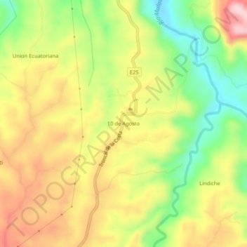
Name: 10 de Agosto topographic map, elevation, terrain.
Average elevation: 689 m
Minimum elevation: 554 m
Maximum elevation: 823 m
Make a donation
Gear up for your next adventure:
As an Amazon Associate, this site earns from qualifying purchases at no extra cost to you.
Other topographic maps
Click on a map to view its topography, its elevation and its terrain.
Santo Domingo
Ecuador > Santo Domingo de los Tsáchilas > Santo Domingo > Santo Domingo de los Tsachilas
Average elevation: 551 m
Río Verde
Ecuador > Santo Domingo de los Tsáchilas > Santo Domingo > Santo Domingo de los Tsachilas
Average elevation: 471 m
Zaracay
Ecuador > Santo Domingo de los Tsáchilas > Santo Domingo > Santo Domingo de los Tsachilas
Average elevation: 561 m