
Make a donation
Gear up for your next adventure:
As an Amazon Associate, this site earns from qualifying purchases at no extra cost to you.
Santo Domingo topographic map
Click on the map to display elevation.
Make a donation
Gear up for your next adventure:
As an Amazon Associate, this site earns from qualifying purchases at no extra cost to you.
About this map
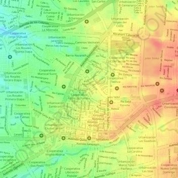
Name: Santo Domingo topographic map, elevation, terrain.
Average elevation: 551 m
Minimum elevation: 514 m
Maximum elevation: 577 m
Make a donation
Gear up for your next adventure:
As an Amazon Associate, this site earns from qualifying purchases at no extra cost to you.
Other topographic maps
Click on a map to view its topography, its elevation and its terrain.
Julio Moreno
Ecuador > Santo Domingo de los Tsáchilas > Santo Domingo > Santo Domingo de los Tsachilas
Average elevation: 480 m
Montañita
Ecuador > Santo Domingo de los Tsáchilas > Santo Domingo > Santo Domingo de los Tsachilas
Average elevation: 374 m
10 de Agosto
Ecuador > Santo Domingo de los Tsáchilas > Santo Domingo > Santo Domingo de los Tsachilas
Average elevation: 689 m
Bombolí
Ecuador > Santo Domingo de los Tsáchilas > Santo Domingo > Santo Domingo de los Tsachilas
Average elevation: 519 m
Make a donation
Gear up for your next adventure:
As an Amazon Associate, this site earns from qualifying purchases at no extra cost to you.
Chiguilpe
Ecuador > Santo Domingo de los Tsáchilas > Santo Domingo > Santo Domingo de los Tsachilas
Average elevation: 427 m
Chiguilpe
Ecuador > Santo Domingo de los Tsáchilas > Santo Domingo > Santo Domingo de los Tsachilas
Average elevation: 677 m
Río Verde
Ecuador > Santo Domingo de los Tsáchilas > Santo Domingo > Santo Domingo de los Tsachilas
Average elevation: 471 m
Río Toachi
Ecuador > Santo Domingo de los Tsáchilas > Santo Domingo > Santo Domingo de los Tsachilas
Average elevation: 399 m
Make a donation
Gear up for your next adventure:
As an Amazon Associate, this site earns from qualifying purchases at no extra cost to you.