Geolocate
👉 Easily get elevation data in JSON, GeoTIFF and KML formats using Elevation API
Thank you for supporting this site ❤️
Make a donation

Agro topographic map

Click on the map to display elevation.

About this map

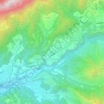
Name: Agro topographic map, elevation, terrain.

Location: Agro, Castione della Presolana, Bergamo, Lombardy, Italy (45.88246 10.00211 45.92246 10.04211)

Average elevation: 924 m

Minimum elevation: 630 m

Maximum elevation: 1,695 m

Other topographic maps

Click on a map to view its topography, its elevation and its terrain.

Mapello

Italy > Lombardy > Bergamo

Average elevation: 271 m

Calusco d'Adda

Italy > Lombardy > Bergamo

Average elevation: 257 m

Gear up for your next adventure:

🦶Hiking Shoe Insoles - Added support for high arches and long days on feet
🧦Outdoor Socks - Durable socks designed for hiking and outdoor sports
🦶Anti-Blister Balm - Prevents friction and hotspots during long ascents
🧤Insulated Winter Gloves - Heavy-duty protection for sub-zero Canadian adventures
Camping Essentials - All-in-one gear for a comfortable camping trip

As an Amazon Associate, this site earns from qualifying purchases at no extra cost to you.