Geolocate

Villanova topographic map

Click on the map to display elevation.

About this map

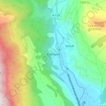
Name: Villanova topographic map, elevation, terrain.

Location: Villanova, La Ribagorza, Huesca, Aragon, Spain (42.52493 0.41666 42.57095 0.48100)

Average elevation: 1,346 m

Minimum elevation: 906 m

Maximum elevation: 2,313 m

Other topographic maps

Click on a map to view its topography, its elevation and its terrain.

Noales

Spain > Aragon > La Ribagorza > Montanuy

Average elevation: 1,217 m

Forcat

Spain > Aragon > La Ribagorza > Montanuy

Average elevation: 1,398 m

Gear up for your next adventure:

👖Convertible Hiking Pants - Zip-off legs to adapt to changing weather conditions
🧥Waterproof Hiking Jacket - Protect yourself from rain and wind while hiking
🧤Rechargeable Heated Gloves - Extreme warmth for Canadian winter expeditions
🛶Waterproof Dry Bags - Keep electronics and clothes dry during river crossings
🧴Sunscreen SPF - Broad-spectrum sunscreen for outdoor activities

As an Amazon Associate, this site earns from qualifying purchases at no extra cost to you.