Geolocate

Brandon topographic map

Click on the map to display elevation.

About this map

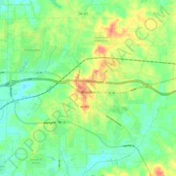
Name: Brandon topographic map, elevation, terrain.

Location: Brandon, Rankin County, Mississippi, 39042, United States (32.23771 -90.04460 32.31302 -89.93268)

Average elevation: 118 m

Minimum elevation: 93 m

Maximum elevation: 162 m

Other topographic maps

Click on a map to view its topography, its elevation and its terrain.

Johns

United States > Mississippi > Rankin County

Average elevation: 118 m

Value

United States > Mississippi > Rankin County > Brandon

Average elevation: 125 m

Lakeland

United States > Mississippi > Rankin County > Richland

Average elevation: 90 m

Leesburg

United States > Mississippi > Rankin County

Average elevation: 112 m

Cleary

United States > Mississippi > Rankin County

Average elevation: 103 m

Lakeshore

United States > Mississippi > Rankin County

Average elevation: 92 m

Plainview

United States > Mississippi > Rankin County > Richland

Average elevation: 96 m

Sinai

United States > Mississippi > Rankin County

Average elevation: 89 m

Gear up for your next adventure:

🥾Light Hiking Boots - Lightweight and comfortable boots for day hikes
🧢Hiking Hat - Sun-protective and breathable hats for long treks
🧥Packable Rain Jacket - Breathable waterproof layer for unpredictable weather
🧴Outdoor Sunscreen - High SPF protection for high-altitude UV exposure
🥾Light Trekking Boots - Supportive boots for multi-day treks

As an Amazon Associate, this site earns from qualifying purchases at no extra cost to you.