Geolocate

Burnie topographic map

Click on the map to display elevation.

About this map

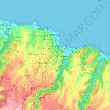
Name: Burnie topographic map, elevation, terrain.

Location: Burnie, City of Burnie, Tasmania, 7320, Australia (-41.11502 145.82192 -41.03551 145.98712)

Average elevation: 99 m

Minimum elevation: 0 m

Maximum elevation: 329 m

Other topographic maps

Click on a map to view its topography, its elevation and its terrain.

Cathedral Mountain

Australia > Tasmania

Average elevation: 992 m

The Nut

Australia > Tasmania > Stanley

Average elevation: 8 m

Waterworks Reserve

Australia > Tasmania > Hobart

Average elevation: 240 m

Rowlands Hill

Australia > Tasmania

Average elevation: 388 m

Bream Creek

Australia > Tasmania > Bream Creek

Average elevation: 35 m

Cradle Mountain

Australia > Tasmania > Cradle Mountain

Average elevation: 1,144 m

West Gawler River

Australia > Tasmania > Sprent > Gawler

Average elevation: 201 m

Mount Patrick

Australia > Tasmania

Average elevation: 863 m

Mount Tyndall

Australia > Tasmania

Average elevation: 910 m

Mount Ossa

Australia > Tasmania

Average elevation: 1,218 m

Gear up for your next adventure:

🧦Crew Hiking Socks - Comfortable socks for long-distance hikes
🚲Bike Repair Kit - Essential tools for on-trail mechanical issues
🔦LED Flashlight - Powerful and long-lasting flashlight for camping and emergencies
🧰Multitool Knife - Compact and versatile tool for outdoor use
🧢Hiking Hat - Sun-protective and breathable hats for long treks

As an Amazon Associate, this site earns from qualifying purchases at no extra cost to you.