Geolocate

Zamora topographic map

Click on the map to display elevation.

About this map

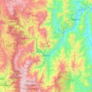
Name: Zamora topographic map, elevation, terrain.

Location: Zamora, Zamora Chinchipe, Ecuador (-4.30511 -79.19580 -3.70317 -78.76306)

Average elevation: 1,928 m

Minimum elevation: 780 m

Maximum elevation: 3,745 m

Other topographic maps

Click on a map to view its topography, its elevation and its terrain.

Water

Ecuador > Zamora Chinchipe > Yacuambi > Tutupali > Santa Rosa

Average elevation: 1,535 m

Loyola

Ecuador > Zamora Chinchipe > Palanda

Average elevation: 1,691 m

Santa Elena

Ecuador > Zamora Chinchipe > Zamora > Zamora

Average elevation: 1,034 m

Gear up for your next adventure:

🧴Outdoor Sunscreen - High SPF protection for high-altitude UV exposure
🗺️Topographic Maps - Detailed maps to explore trails, mountains, and wilderness areas
🥾Trekking Poles - Adjustable trekking poles to reduce knee stress and improve stability
🧥Softshell Hiking Jacket - The perfect balance of wind protection and breathability
Tent Footprint - Protect tent floor and increase durability

As an Amazon Associate, this site earns from qualifying purchases at no extra cost to you.