
Thank you for supporting this site ❤️
Make a donation
Make a donation
Gear up for your next adventure:
As an Amazon Associate, this site earns from qualifying purchases at no extra cost to you.
Wittichenau - Kulow topographic map
Click on the map to display elevation.
Thank you for supporting this site ❤️
Make a donation
Make a donation
Gear up for your next adventure:
As an Amazon Associate, this site earns from qualifying purchases at no extra cost to you.
About this map
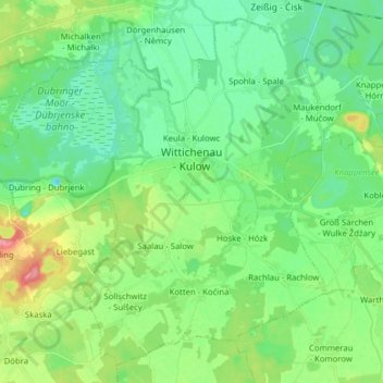
Name: Wittichenau - Kulow topographic map, elevation, terrain.
Location: Wittichenau - Kulow, Bautzen, Saxony, 02997, Germany (51.33241 14.16072 51.42103 14.31750)
Average elevation: 130 m
Minimum elevation: 106 m
Maximum elevation: 190 m
Thank you for supporting this site ❤️
Make a donation
Make a donation
Gear up for your next adventure:
As an Amazon Associate, this site earns from qualifying purchases at no extra cost to you.
Other topographic maps
Click on a map to view its topography, its elevation and its terrain.
Koselbruch - Kózło
Germany > Saxony > Bautzen > Hoyerswerda - Wojerecy > Schwarzkollm - Čorny Chołmc
Average elevation: 133 m