
Saint-Benoît topographic map
Interactive map
Click on the map to display elevation.
About this map
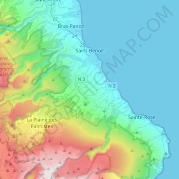
Name: Saint-Benoît topographic map, elevation, terrain.
Location: Saint-Benoît, Réunion, France (-21.17230 55.49514 -21.00498 55.76734)
Average elevation: 561 m
Minimum elevation: 0 m
Maximum elevation: 2,445 m
Other topographic maps
Click on a map to view its topography, its elevation and its terrain.
Plateau Goyaves
France > Réunion > Saint-Louis > Plateau Goyaves
Plateau Goyaves, Saint-Louis, Saint-Pierre, Réunion, 97450, France
Average elevation: 101 m
Gîte du Volcan
France > Réunion > Sainte-Rose
Gîte du Volcan, Sentier du Fond de la Rivière de l'Est, Sainte-Rose, Saint-Benoît, Réunion, 97439, France
Average elevation: 2,127 m
Hell Bourg
France > Réunion > Hell Bourg
Hell-Bourg, Hell Bourg, Saint-Benoît, Réunion, 97433, France
Average elevation: 1,132 m
Takamaka
France > Réunion > Saint-Benoît
Takamaka, Chemin Grand Fond, Saint-Benoît, Réunion, 97431, France
Average elevation: 851 m
Hell Bourg
France > Réunion > Hell Bourg
Hell Bourg, Saint-Benoît, Réunion, France
Average elevation: 1,039 m
Roche Écrite
France > Réunion > Saint-Denis
Roche Écrite, Saint-Denis, Réunion, France
Average elevation: 1,589 m
Piton de la Fournaise
France > Réunion > Saint-Philippe
Piton de la Fournaise, Saint-Philippe, Saint-Pierre, Réunion, 97442, France
Average elevation: 2,352 m