Geolocate

Saint-Leu topographic map

Click on the map to display elevation.

About this map

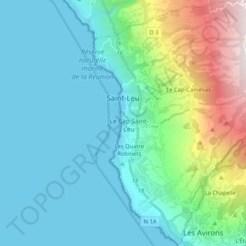
Name: Saint-Leu topographic map, elevation, terrain.

Location: Saint-Leu, Saint-Paul, Réunion, France (-21.24924 55.27021 -21.11404 55.41598)

Average elevation: 360 m

Minimum elevation: 0 m

Maximum elevation: 1,822 m

Gear up for your next adventure:

🥾Hiking Leggings - Comfortable leggings for outdoor activities
🥤Collapsible Travel Cup - Saves space and weight in your mess kit
🥾Trekking Boots - Durable boots for long-distance trekking
🥾Light Trekking Boots - Supportive boots for multi-day treks
🔦LED Headlamp - Hands-free lighting for early morning starts or late finishes

As an Amazon Associate, this site earns from qualifying purchases at no extra cost to you.