Make a donation
Gear up for your next adventure:
As an Amazon Associate, this site earns from qualifying purchases at no extra cost to you.
Pointe du Bois topographic map
Click on the map to display elevation.
Make a donation
Gear up for your next adventure:
As an Amazon Associate, this site earns from qualifying purchases at no extra cost to you.
About this map
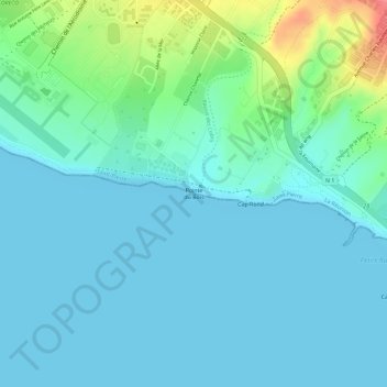
Name: Pointe du Bois topographic map, elevation, terrain.
Location: Pointe du Bois, Réunion, 97451, France (-21.32759 55.43933 -21.32749 55.43943)
Average elevation: 15 m
Minimum elevation: 0 m
Maximum elevation: 73 m
Make a donation
Gear up for your next adventure:
As an Amazon Associate, this site earns from qualifying purchases at no extra cost to you.
Other topographic maps
Click on a map to view its topography, its elevation and its terrain.
Réunion
Already at the time of the India Route or Route des Indes, Réunion was a French possession located between Cape Town and the Indian trading posts, although far from the Mozambique Channel. Île de Bourbon (its name under the Ancien Régime) was not, however, the preferred position for trade and military.…
Average elevation: 532 m
Make a donation
Gear up for your next adventure:
As an Amazon Associate, this site earns from qualifying purchases at no extra cost to you.
