Geolocate

Sandnes topographic map

Click on the map to display elevation.

About this map

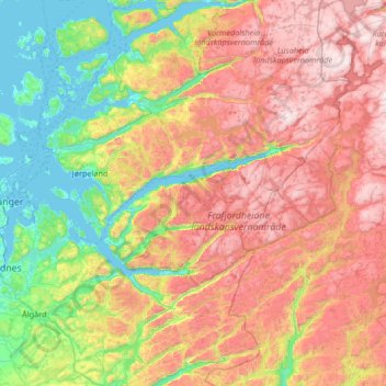
Name: Sandnes topographic map, elevation, terrain.

Location: Sandnes, Rogaland, Norway (58.77681 5.60971 59.19259 6.93917)

Average elevation: 523 m

Minimum elevation: -1 m

Maximum elevation: 1,335 m

Other topographic maps

Click on a map to view its topography, its elevation and its terrain.

Haugesund

Norway > Rogaland

Average elevation: 24 m

Storasund

Norway > Rogaland

Average elevation: 20 m

Lysebotn

Norway > Rogaland > Lysebotn

Average elevation: 500 m

Gear up for your next adventure:

🔋Solar Power Bank - Keep your GPS and devices charged during long outdoor trips
🥾Hiking Gaiters - Protect legs and shoes from mud, snow, and debris
🥾Mountaineering Boots - Supportive boots for climbing and high-altitude hiking
🧼Travel Hand Sanitizer - Keep hands clean when water is scarce
🛌Insulated Sleeping Pad - Critical thermal barrier between you and the cold ground

As an Amazon Associate, this site earns from qualifying purchases at no extra cost to you.