Geolocate

Litlit topographic map

Click on the map to display elevation.

About this map

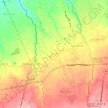
Name: Litlit topographic map, elevation, terrain.

Location: Litlit, Silang, Cavite, Calabarzon, 4118, Philippines (14.18574 120.92420 14.22574 120.96420)

Average elevation: 343 m

Minimum elevation: 261 m

Maximum elevation: 397 m

Other topographic maps

Click on a map to view its topography, its elevation and its terrain.

Carmen

Philippines > Cavite > Silang

Average elevation: 172 m

Carmen

Philippines > Cavite > Silang

Average elevation: 172 m

Gear up for your next adventure:

🧴First Aid Kit - Essential first aid supplies for outdoor emergencies
🥾Waterproof Hiking Boots - Boots keeping your feet dry in wet conditions
🧦Hiking Socks - Moisture-wicking and comfortable socks for long hikes
🗺️Topographic Maps - Detailed maps to explore trails, mountains, and wilderness areas
🧴Outdoor Sunscreen - High SPF protection for high-altitude UV exposure

As an Amazon Associate, this site earns from qualifying purchases at no extra cost to you.