
Make a donation
Gear up for your next adventure:
As an Amazon Associate, this site earns from qualifying purchases at no extra cost to you.
Buckland Four Corners topographic map
Click on the map to display elevation.
Make a donation
Gear up for your next adventure:
As an Amazon Associate, this site earns from qualifying purchases at no extra cost to you.
About this map
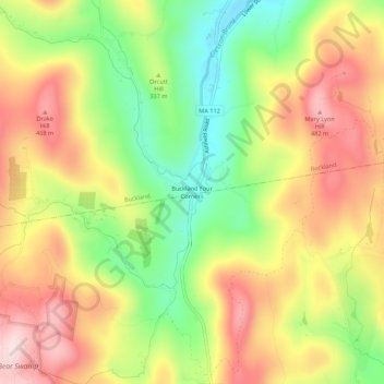
Name: Buckland Four Corners topographic map, elevation, terrain.
Average elevation: 346 m
Minimum elevation: 185 m
Maximum elevation: 501 m
Make a donation
Gear up for your next adventure:
As an Amazon Associate, this site earns from qualifying purchases at no extra cost to you.
Other topographic maps
Click on a map to view its topography, its elevation and its terrain.
Leverett
United States > Massachusetts > Franklin County
According to the United States Census Bureau, the town has a total area of 23.0 square miles (60 km2), of which 22.9 square miles (59 km2) are land and 0.1-square-mile (0.26 km2) (0.61%) is water. Leverett is located on the edge of the Pioneer Valley and the hills of northwestern Massachusetts, just east of…
Average elevation: 220 m
Doolittle Brook Conservation Area
United States > Massachusetts > Franklin County > Leverett
Average elevation: 192 m
Make a donation
Gear up for your next adventure:
As an Amazon Associate, this site earns from qualifying purchases at no extra cost to you.