
Beuron topographic map
Interactive map
Click on the map to display elevation.
About this map
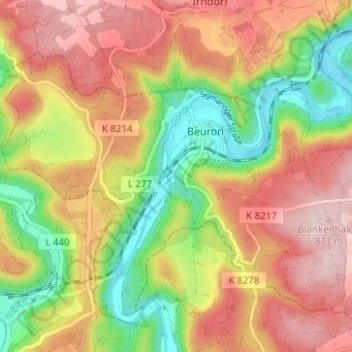
Name: Beuron topographic map, elevation, terrain.
Average elevation: 745 m
Minimum elevation: 599 m
Maximum elevation: 875 m
Der gesamte Wald liegt im FFH-Gebiet Obere Donau, der Biotopanteil ist vier Mal höher als im Landesschnitt. Er ist Lebensraum für Rehe und Gämsen.
Other topographic maps
Click on a map to view its topography, its elevation and its terrain.
Hausen im Tal
Deutschland > Baden-Württemberg > Landkreis Sigmaringen > Beuron
Hausen im Tal, Beuron, Gemeindeverwaltungsverband Sigmaringen, Landkreis Sigmaringen, Baden-Württemberg, 88631, Deutschland
Average elevation: 751 m