Geolocate

Petal topographic map

Click on the map to display elevation.

About this map

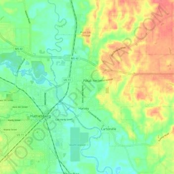
Name: Petal topographic map, elevation, terrain.

Location: Petal, Forrest County, Mississippi, 39465, United States (31.31030 -89.28618 31.37589 -89.17334)

Average elevation: 57 m

Minimum elevation: 32 m

Maximum elevation: 93 m

Other topographic maps

Click on a map to view its topography, its elevation and its terrain.

Barrontown

United States > Mississippi > Forrest County

Average elevation: 80 m

McLaurin

United States > Mississippi > Forrest County

Average elevation: 92 m

Gear up for your next adventure:

🧥Softshell Jacket - Windproof and breathable jacket for hiking
💡Portable Camping Lamp - Rechargeable lamp for campsite lighting
🥾Approach Shoes - Shoes designed for climbing approaches and rugged trails
🧰Emergency Multi-Tool - Compact multi-tool for outdoor survival
🥾Waterproof Hiking Shoes - Durable shoes for wet and rugged trails

As an Amazon Associate, this site earns from qualifying purchases at no extra cost to you.