Geolocate

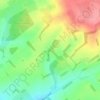
Bighton topographic map

Click on the map to display elevation.

About this map

Name: Bighton topographic map, elevation, terrain.

Location: Bighton, Winchester, Hampshire, England, United Kingdom (51.09092 -1.14892 51.12544 -1.07209)

Average elevation: 121 m

Minimum elevation: 65 m

Maximum elevation: 197 m

Other topographic maps

Click on a map to view its topography, its elevation and its terrain.
Bighton Wood

United Kingdom > England > Hampshire > Winchester > Bighton

Average elevation: 135 m

Gear up for your next adventure:

🔦LED Flashlight - Powerful and long-lasting flashlight for camping and emergencies
🏃Hydration Running Vest - Carry water and maps close to your body for speed
🛶Canoe Life Vest - Safety vest for water sports
🥾Hiking Shorts - Breathable shorts suitable for summer hikes
🧢Outdoor Cap - Protective cap for sun and rain during hikes

As an Amazon Associate, this site earns from qualifying purchases at no extra cost to you.