
Make a donation
Gear up for your next adventure:
As an Amazon Associate, this site earns from qualifying purchases at no extra cost to you.
Le Grand Marchais topographic map
Click on the map to display elevation.
Make a donation
Gear up for your next adventure:
As an Amazon Associate, this site earns from qualifying purchases at no extra cost to you.
About this map
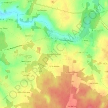
Name: Le Grand Marchais topographic map, elevation, terrain.
Average elevation: 185 m
Minimum elevation: 149 m
Maximum elevation: 213 m
Make a donation
Gear up for your next adventure:
As an Amazon Associate, this site earns from qualifying purchases at no extra cost to you.
Other topographic maps
Click on a map to view its topography, its elevation and its terrain.
Saint-Martin-sur-Ouanne
France > Bourgogne-Franche-Comté > Yonne > Charny Orée de Puisaye
La superficie de la commune est de 1 534 hectares ; son altitude varie entre 136 et 202 mètres.
Average elevation: 176 m
Make a donation
Gear up for your next adventure:
As an Amazon Associate, this site earns from qualifying purchases at no extra cost to you.
Villefranche
France > Bourgogne-Franche-Comté > Yonne > Charny Orée de Puisaye
Average elevation: 179 m