
Make a donation
Gear up for your next adventure:
As an Amazon Associate, this site earns from qualifying purchases at no extra cost to you.
Chevillon topographic map
Click on the map to display elevation.
Make a donation
Gear up for your next adventure:
As an Amazon Associate, this site earns from qualifying purchases at no extra cost to you.
About this map
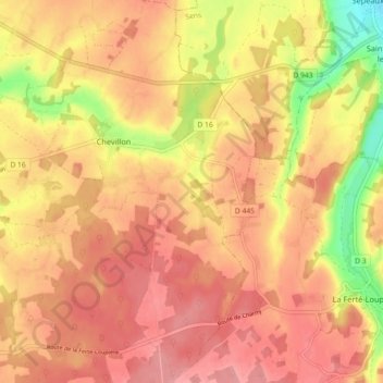
Name: Chevillon topographic map, elevation, terrain.
Average elevation: 185 m
Minimum elevation: 118 m
Maximum elevation: 218 m
Make a donation
Gear up for your next adventure:
As an Amazon Associate, this site earns from qualifying purchases at no extra cost to you.
Other topographic maps
Click on a map to view its topography, its elevation and its terrain.
Les Fleuris
France > Bourgogne-Franche-Comté > Yonne > Charny Orée de Puisaye > Malicorne
Average elevation: 179 m
Le Grand Marchais
France > Bourgogne-Franche-Comté > Yonne > Charny Orée de Puisaye
Average elevation: 185 m
Malvrain
France > Bourgogne-Franche-Comté > Yonne > Charny Orée de Puisaye > Prunoy
Average elevation: 186 m
Les Cochards
France > Bourgogne-Franche-Comté > Yonne > Charny Orée de Puisaye > Charny
Average elevation: 168 m
Make a donation
Gear up for your next adventure:
As an Amazon Associate, this site earns from qualifying purchases at no extra cost to you.
Les Petits Brossards
France > Bourgogne-Franche-Comté > Yonne > Charny Orée de Puisaye > Grandchamp
Average elevation: 201 m
Les Morins
France > Bourgogne-Franche-Comté > Yonne > Charny Orée de Puisaye > Malicorne
Average elevation: 178 m
Make a donation
Gear up for your next adventure:
As an Amazon Associate, this site earns from qualifying purchases at no extra cost to you.