Geolocate

Moreland topographic map

Click on the map to display elevation.

About this map

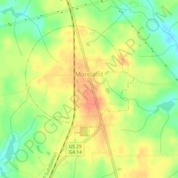
Name: Moreland topographic map, elevation, terrain.

Location: Moreland, Coweta County, Georgia, United States (33.27498 -84.77929 33.29409 -84.75950)

Average elevation: 277 m

Minimum elevation: 252 m

Maximum elevation: 297 m

Other topographic maps

Click on a map to view its topography, its elevation and its terrain.

East Newnan

United States > Georgia > Coweta County

Average elevation: 290 m

Arnco Mills

United States > Georgia > Coweta County

Average elevation: 256 m

McBride

United States > Georgia > Coweta County > Newnan

Average elevation: 280 m

McCollum

United States > Georgia > Coweta County

Average elevation: 284 m

Gear up for your next adventure:

🥾Hiking Gaiters - Protect legs and shoes from mud, snow, and debris
🧴First Aid Kit - Essential first aid supplies for outdoor emergencies
Family Camping Tent - Spacious tent suitable for family camping trips
🧥Waterproof Jacket - Lightweight rain jackets for hiking and outdoor activities
🛰️Satellite Messenger - Emergency communication for areas with no cell service

As an Amazon Associate, this site earns from qualifying purchases at no extra cost to you.