Geolocate

Saint-Sulpice topographic map

Click on the map to display elevation.

About this map
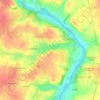
Name: Saint-Sulpice topographic map, elevation, terrain.

Location: Saint-Sulpice, La Roche-Neuville, Château-Gontier, Mayenne, Pays de la Loire, France métropolitaine, 53360, France (47.88078 -0.74566 47.91094 -0.68967)

Average elevation: 68 m

Minimum elevation: 28 m

Maximum elevation: 98 m

Other topographic maps

Click on a map to view its topography, its elevation and its terrain.
Neuville

France > Pays de la Loire > Mayenne > La Roche-Neuville

Average elevation: 69 m

Gear up for your next adventure:

🧰Multitool Knife - Compact and versatile tool for outdoor use
🔪Outdoor Multitool - Versatile tool for repairs and food prep in the wild
👟Trail Running Shoes - Agile footwear for fast-paced topographic exploration
🥾Trekking Boots - Durable boots for long-distance trekking
🦟Insect Repellent - Keep mosquitoes and black flies away in wooded areas

As an Amazon Associate, this site earns from qualifying purchases at no extra cost to you.