Geolocate

Nyeri topographic map

Click on the map to display elevation.

About this map

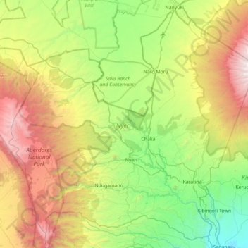
Name: Nyeri topographic map, elevation, terrain.

Location: Nyeri, Kenya (-0.64687 36.60474 0.01042 37.30854)

Average elevation: 2,218 m

Minimum elevation: 1,162 m

Maximum elevation: 4,339 m

Other topographic maps

Click on a map to view its topography, its elevation and its terrain.

Kĩricũ Town

Kenya > Nyeri > Nyeri Central

Average elevation: 1,712 m

Karatina

Kenya > Nyeri > Mathira West

Average elevation: 1,738 m

Kĩricũ Town

Kenya > Nyeri > Nyeri Central

Average elevation: 1,712 m

Aberdares National Park

Kenya > Nyeri > Kieni West

Average elevation: 2,484 m

Kiawara

Kenya > Nyeri > Kieni West

Average elevation: 2,041 m

Wamagana

Kenya > Nyeri > Tetu

Average elevation: 1,871 m

Karĩma Hill

Kenya > Nyeri > Othaya

Average elevation: 1,832 m

Mweiga

Kenya > Nyeri > Kieni West

Average elevation: 1,948 m

Karatina

Kenya > Nyeri > Mathira West

Average elevation: 1,738 m

Gear up for your next adventure:

🛌Insulated Sleeping Pad - Critical thermal barrier between you and the cold ground
🪜Heavy Duty Carabiners - Multi-use clips for securing gear to your backpack
🔭Outdoor Binoculars - Lightweight binoculars for birdwatching and hiking
🦟Insect Repellent - Keep mosquitoes and black flies away in wooded areas
🧼Travel Hand Sanitizer - Keep hands clean when water is scarce

As an Amazon Associate, this site earns from qualifying purchases at no extra cost to you.