Geolocate

Mweiga topographic map

Click on the map to display elevation.

About this map

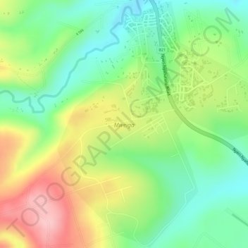
Name: Mweiga topographic map, elevation, terrain.

Location: Mweiga, Kieni West, Nyeri, 10104, Kenya (-0.34433 36.89196 -0.31752 36.91386)

Average elevation: 1,948 m

Minimum elevation: 1,873 m

Maximum elevation: 2,043 m

Other topographic maps

Click on a map to view its topography, its elevation and its terrain.

Kiawara

Kenya > Nyeri > Kieni West

Average elevation: 2,041 m

Gear up for your next adventure:

🏃Hydration Running Vest - Carry water and maps close to your body for speed
🏕️Camping Hammock - Integrated protection for sleeping between trees
🧥Thermal Layer - Insulating layer for cold outdoor conditions
🥾Hiking Shoes - Durable and comfortable shoes for trail hiking
🧭GPS Tracker - Track your location in remote areas safely

As an Amazon Associate, this site earns from qualifying purchases at no extra cost to you.