
Make a donation
Gear up for your next adventure:
As an Amazon Associate, this site earns from qualifying purchases at no extra cost to you.
Magadino topographic map
Click on the map to display elevation.
Make a donation
Gear up for your next adventure:
As an Amazon Associate, this site earns from qualifying purchases at no extra cost to you.
About this map
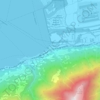
Name: Magadino topographic map, elevation, terrain.
Average elevation: 438 m
Minimum elevation: 190 m
Maximum elevation: 1,583 m
Make a donation
Gear up for your next adventure:
As an Amazon Associate, this site earns from qualifying purchases at no extra cost to you.
Other topographic maps
Click on a map to view its topography, its elevation and its terrain.
Locarno
Switzerland > Ticino > Distretto di Locarno
The municipality is the capital of its district. Locarno is located on the left shore of Lake Maggiore. The city is made up of the old town (historic settlement centre), the new town (Nuovo quartiere) toward the lake and the land district (quartiere Campagna) toward Solduno. The area of the municipality…
Average elevation: 604 m
Make a donation
Gear up for your next adventure:
As an Amazon Associate, this site earns from qualifying purchases at no extra cost to you.
Valle Verzasca
Switzerland > Ticino > Distretto di Locarno > Verzasca
Located between the Leventina and the Valle Maggia valleys, Valle Verzasca extends over a length of 25 kilometres (16 mi) in north–south direction and is situated in the north of the Lago Maggiore. The valley floor is at about 500 metres (1,640 ft) to 900 metres (2,953 ft) above sea level. The surrounding…
Average elevation: 1,398 m