
Make a donation
Gear up for your next adventure:
As an Amazon Associate, this site earns from qualifying purchases at no extra cost to you.
Le Val topographic map
Click on the map to display elevation.
Make a donation
Gear up for your next adventure:
As an Amazon Associate, this site earns from qualifying purchases at no extra cost to you.
About this map
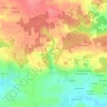
Name: Le Val topographic map, elevation, terrain.
Average elevation: 92 m
Minimum elevation: 46 m
Maximum elevation: 129 m
Make a donation
Gear up for your next adventure:
As an Amazon Associate, this site earns from qualifying purchases at no extra cost to you.
Other topographic maps
Click on a map to view its topography, its elevation and its terrain.
Campel
France > Bretagne > Ille-et-Vilaine > Val d'Anast
Le territoire de cette ancienne commune s'étendait sur le versant sud d'une ligne de collines marquant la limite septentrionale du pays d'Anast ; les altitudes avoisinent 100 mètres au nord, approximativement entre Brémont et la Bigotais, et descend par un coteau au flanc duquel le bourg est implanté ; les…
Average elevation: 87 m