
Make a donation
Gear up for your next adventure:
As an Amazon Associate, this site earns from qualifying purchases at no extra cost to you.
Campel topographic map
Click on the map to display elevation.
Make a donation
Gear up for your next adventure:
As an Amazon Associate, this site earns from qualifying purchases at no extra cost to you.
Campel
Le territoire de cette ancienne commune s'étendait sur le versant sud d'une ligne de collines marquant la limite septentrionale du pays d'Anast ; les altitudes avoisinent 100 mètres au nord, approximativement entre Brémont et la Bigotais, et descend par un coteau au flanc duquel le bourg est implanté ; les terres bosselées du sud ont une altitude moyenne d'une soixantaine de mètres.
Make a donation
Gear up for your next adventure:
As an Amazon Associate, this site earns from qualifying purchases at no extra cost to you.
About this map
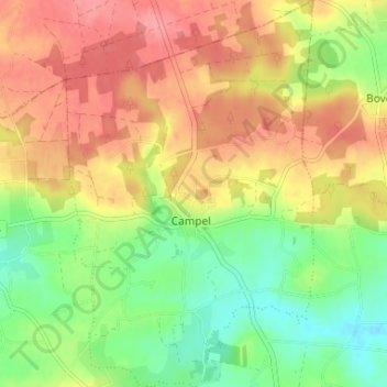
Name: Campel topographic map, elevation, terrain.
Average elevation: 87 m
Minimum elevation: 43 m
Maximum elevation: 129 m
Make a donation
Gear up for your next adventure:
As an Amazon Associate, this site earns from qualifying purchases at no extra cost to you.
Other topographic maps
Click on a map to view its topography, its elevation and its terrain.