Geolocate

Davis Store topographic map

Click on the map to display elevation.

About this map

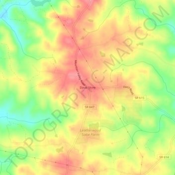
Name: Davis Store topographic map, elevation, terrain.

Location: Davis Store, Henry County, Virginia, United States (36.67569 -79.72809 36.71569 -79.68809)

Average elevation: 280 m

Minimum elevation: 229 m

Maximum elevation: 318 m

Other topographic maps

Click on a map to view its topography, its elevation and its terrain.

Oak Level

United States > Virginia > Henry County

Average elevation: 327 m

Sandy Level

United States > Virginia > Henry County > Sandy Level

Average elevation: 210 m

Stanleytown

United States > Virginia > Henry County

Average elevation: 259 m

Chatmoss

United States > Virginia > Henry County

Average elevation: 244 m

Laurel Park

United States > Virginia > Henry County

Average elevation: 228 m

Gear up for your next adventure:

🎒Hiking Backpack - Lightweight and ergonomic backpacks for day hikes or multi-day treks
🔋Lithium AA Batteries - Long-lasting power that performs in extreme cold
📷Outdoor Action Camera - Capture high-elevation views and rugged adventures
🥾Mountain Hiking Shoes - Shoes with superior grip for mountainous terrain
🥾Hiking Shorts - Breathable shorts suitable for summer hikes

As an Amazon Associate, this site earns from qualifying purchases at no extra cost to you.