Geolocate

Villa Heights topographic map

Click on the map to display elevation.

About this map

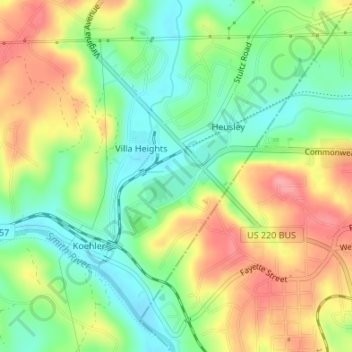
Name: Villa Heights topographic map, elevation, terrain.

Location: Villa Heights, Henry County, Virginia, United States (36.68413 -79.90910 36.70629 -79.88557)

Average elevation: 256 m

Minimum elevation: 213 m

Maximum elevation: 308 m

Gear up for your next adventure:

🧥Softshell Hiking Jacket - The perfect balance of wind protection and breathability
🧦Thermal Socks - Warm socks for winter hiking or camping
🦟Insect Repellent - Keep mosquitoes and black flies away in wooded areas
🧭GPS Handheld Device - Reliable GPS navigation for outdoor adventures
🥾Waterproof Trail Shoes - Shoes designed to handle wet terrain

As an Amazon Associate, this site earns from qualifying purchases at no extra cost to you.