Geolocate

Bobo topographic map

Click on the map to display elevation.

About this map

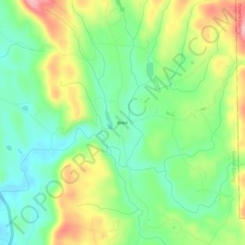
Name: Bobo topographic map, elevation, terrain.

Location: Bobo, Gordon County, Georgia, 30734, United States (34.45854 -84.69620 34.49854 -84.65620)

Average elevation: 278 m

Minimum elevation: 215 m

Maximum elevation: 380 m

Other topographic maps

Click on a map to view its topography, its elevation and its terrain.

Plainville

United States > Georgia > Gordon County

Average elevation: 213 m

Resaca

United States > Georgia > Gordon County

Average elevation: 199 m

Fairmount

United States > Georgia > Gordon County

Average elevation: 249 m

Ranger

United States > Georgia > Gordon County > Ranger

Average elevation: 246 m

Fairmount

United States > Georgia > Gordon County

Average elevation: 249 m

Calhoun

United States > Georgia > Gordon County

Average elevation: 210 m

Fairmount

United States > Georgia > Gordon County

Average elevation: 249 m

Gear up for your next adventure:

🧤Insulated Winter Gloves - Heavy-duty protection for sub-zero Canadian adventures
🧦Outdoor Socks - Durable socks designed for hiking and outdoor sports
🥾Hiking Gaiters - Protect legs and shoes from mud, snow, and debris
🧼Travel Hand Sanitizer - Keep hands clean when water is scarce
🛶Kayak Accessories - Essential gear for safe and fun kayaking adventures

As an Amazon Associate, this site earns from qualifying purchases at no extra cost to you.