Geolocate

Beicun topographic map

Click on the map to display elevation.

About this map

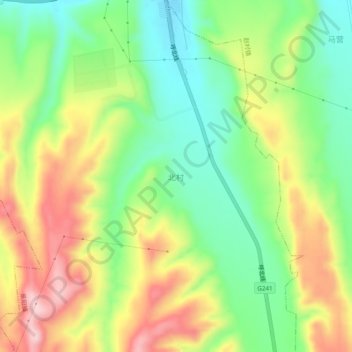
Name: Beicun topographic map, elevation, terrain.

Location: Beicun, Luoyang, Henan, China (34.30032 111.53150 34.34032 111.57150)

Average elevation: 469 m

Minimum elevation: 364 m

Maximum elevation: 607 m

Other topographic maps

Click on a map to view its topography, its elevation and its terrain.

Xin'an County

China > Henan > Luoyang

Average elevation: 423 m

Yanshi District

China > Henan > Luoyang

Average elevation: 271 m

Yichuan County

China > Henan > Luoyang

Average elevation: 335 m

Song County

China > Henan > Luoyang

Average elevation: 773 m

Song County

China > Henan > Luoyang

Average elevation: 773 m

Yanshi District

China > Henan > Luoyang

Average elevation: 271 m

Gear up for your next adventure:

🛶Canoe Life Vest - Safety vest for water sports
🥾Mountain Hiking Shoes - Shoes with superior grip for mountainous terrain
🎒Hiking Daypack - Lightweight and durable backpacks for day trips and excursions
🥾Trail Hiking Shoes - Durable shoes designed for rugged trails
💡Compact LED Flashlight - Powerful and portable flashlight for outdoor use

As an Amazon Associate, this site earns from qualifying purchases at no extra cost to you.