
Make a donation
Gear up for your next adventure:
As an Amazon Associate, this site earns from qualifying purchases at no extra cost to you.
Zakarpattia Oblast topographic map
Click on the map to display elevation.
Make a donation
Gear up for your next adventure:
As an Amazon Associate, this site earns from qualifying purchases at no extra cost to you.
Zakarpattia Oblast
The oblast's name Zakarpattia (Ukrainian: Закарпаття, romanized: Zakarpattia), which translates as "Transcarpathian" or literally "beyond the Carpathians," refers to its location on the western side of the Carpathian Mountains, a major mountain range that forms an arc across Central and Southeast Europe. As a result, the oblast is also often called Transcarpathian Oblast or Transcarpathia, although the historical region of Transcarpathia also includes areas outside the oblast, specifically small parts of Slovakia (mostly in Prešov Region and Košice Region) as well as Poland's Lemko Region. Other historical names for both the oblast and broader region include Transcarpathian Ruthenia, Transcarpathian Ukraine, and Carpathian Ruthenia. The region is also sometimes referred to as "Subcarpathian" (which translates literally to "below (or "feet of") the Carpathians"), such as in Subcarpathian Rus' and Subcarpathia. This name refers to the area's location in the lower-elevation Carpathian Basin (also known as the Pannonian Basin) and is also a reference to the largely overlapping physical geographical region of Prykarpattia (the Ukrainian name for Ciscarpathia), which encompasses the northeastern foothills of the Carpathian Mountains.
Make a donation
Gear up for your next adventure:
As an Amazon Associate, this site earns from qualifying purchases at no extra cost to you.
About this map
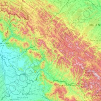
Name: Zakarpattia Oblast topographic map, elevation, terrain.
Location: Zakarpattia Oblast, Ukraine (47.89689 22.13706 49.09732 24.62747)
Average elevation: 548 m
Minimum elevation: 101 m
Maximum elevation: 1,978 m
Make a donation
Gear up for your next adventure:
As an Amazon Associate, this site earns from qualifying purchases at no extra cost to you.
Other topographic maps
Click on a map to view its topography, its elevation and its terrain.
Make a donation
Gear up for your next adventure:
As an Amazon Associate, this site earns from qualifying purchases at no extra cost to you.
Make a donation
Gear up for your next adventure:
As an Amazon Associate, this site earns from qualifying purchases at no extra cost to you.
Make a donation
Gear up for your next adventure:
As an Amazon Associate, this site earns from qualifying purchases at no extra cost to you.
Hoverla
In the 20th century, the mountain increasingly gained popularity as an extreme sports site. Some routes are classified as 1A in the winter period (from late autumn to May), according to the Soviet grading system. The most popular approach to the summit starts from the tour-basa Zarosliak on the mountain's…
Average elevation: 1,667 m
Make a donation
Gear up for your next adventure:
As an Amazon Associate, this site earns from qualifying purchases at no extra cost to you.
Make a donation
Gear up for your next adventure:
As an Amazon Associate, this site earns from qualifying purchases at no extra cost to you.
Verecke Pass
The pass is located in the Carpathian Mountains just where the oblasts of Lviv and Transcarpathia meet, on the spine of the Northeastern Carpathians, between the Latorica (or Latorytsia) and Opir river valleys and at the river divide or watershed between the Latorytsia and the Stryi. It has an elevation of 841…
Average elevation: 749 m
Make a donation
Gear up for your next adventure:
As an Amazon Associate, this site earns from qualifying purchases at no extra cost to you.
Make a donation
Gear up for your next adventure:
As an Amazon Associate, this site earns from qualifying purchases at no extra cost to you.
Make a donation
Gear up for your next adventure:
As an Amazon Associate, this site earns from qualifying purchases at no extra cost to you.
Make a donation
Gear up for your next adventure:
As an Amazon Associate, this site earns from qualifying purchases at no extra cost to you.
Make a donation
Gear up for your next adventure:
As an Amazon Associate, this site earns from qualifying purchases at no extra cost to you.
Kolodiivka
It is located in the southernmost portion of the oblast on the Dnister River at an elevation of 273 m (896 ft). The village maintains its own local government as the Kolodiivka Rural Council (Ukrainian: Колодіївська сільська рада), which consists of 21 locally elected deputies.
Average elevation: 252 m
Make a donation
Gear up for your next adventure:
As an Amazon Associate, this site earns from qualifying purchases at no extra cost to you.
Make a donation
Gear up for your next adventure:
As an Amazon Associate, this site earns from qualifying purchases at no extra cost to you.
Булганакское сопковое поле (Грязевые вулканы)
Ukraine > Autonomous Republic of Crimea > Lenine Raion > Войковское сельское поселение
Average elevation: 75 m
Make a donation
Gear up for your next adventure:
As an Amazon Associate, this site earns from qualifying purchases at no extra cost to you.
Make a donation
Gear up for your next adventure:
As an Amazon Associate, this site earns from qualifying purchases at no extra cost to you.
Make a donation
Gear up for your next adventure:
As an Amazon Associate, this site earns from qualifying purchases at no extra cost to you.
Make a donation
Gear up for your next adventure:
As an Amazon Associate, this site earns from qualifying purchases at no extra cost to you.
Basivka
The village covers an area of 2,39 km2 at an altitude of 305 metres (1,000 ft) above sea level. The population of village is just about 1042 persons and local government is administered by the Hodovytsko-Basivska village council.
Average elevation: 318 m
Make a donation
Gear up for your next adventure:
As an Amazon Associate, this site earns from qualifying purchases at no extra cost to you.
Make a donation
Gear up for your next adventure:
As an Amazon Associate, this site earns from qualifying purchases at no extra cost to you.
Make a donation
Gear up for your next adventure:
As an Amazon Associate, this site earns from qualifying purchases at no extra cost to you.
Libknekhtovka
Ukraine > Autonomous Republic of Crimea > Керченський район > Чистопольское сельское поселение
Average elevation: 127 m
Make a donation
Gear up for your next adventure:
As an Amazon Associate, this site earns from qualifying purchases at no extra cost to you.
Make a donation
Gear up for your next adventure:
As an Amazon Associate, this site earns from qualifying purchases at no extra cost to you.
Make a donation
Gear up for your next adventure:
As an Amazon Associate, this site earns from qualifying purchases at no extra cost to you.
Make a donation
Gear up for your next adventure:
As an Amazon Associate, this site earns from qualifying purchases at no extra cost to you.
Dnipro
The source of the Dnieper is the sedge bogs (Akseninsky Mokh) of the Valdai Hills in central Russia, at an elevation of 220 m (720 ft). For 115 km (71 mi) of its length, it serves as the border between Belarus and Ukraine. Its estuary, or liman, used to be defended by the strong fortress of Ochakiv.
Average elevation: 108 m
Make a donation
Gear up for your next adventure:
As an Amazon Associate, this site earns from qualifying purchases at no extra cost to you.
Rivnopillia
Ukraine > Republic of Crimea > Simferopol District > Кольчугинское сельское поселение
Average elevation: 64 m
Make a donation
Gear up for your next adventure:
As an Amazon Associate, this site earns from qualifying purchases at no extra cost to you.