Geolocate

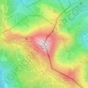
Hoverla topographic map

Click on the map to display elevation.

Hoverla

In the 20th century, the mountain increasingly gained popularity as an extreme sports site. Some routes are classified as 1A in the winter period (from late autumn to May), according to the Soviet grading system. The most popular approach to the summit starts from the tour-basa Zarosliak on the mountain's eastern face and gains more than 1,100 m (3,600 ft) elevation along a steep path with few hairpin turns. There is a steeper route (marked with blue signs) and a gentler, longer one (marked with green).

Wikipedia (CC-BY-SA 3.0)

About this map

Name: Hoverla topographic map, elevation, terrain.

Location: Hoverla, Yasinia Settlement Hromada, Rakhiv Raion, Ukraine (48.16016 24.49989 48.16026 24.49999)

Average elevation: 1,667 m

Minimum elevation: 1,352 m

Maximum elevation: 2,052 m

Other topographic maps

Click on a map to view its topography, its elevation and its terrain.

Donetsk

Ukraine > Donetsk Oblast

Average elevation: 196 m

Pukhova

Ukraine > Rivne Oblast

Average elevation: 189 m

Odesa

Ukraine > Odesa Oblast

Odesa is situated (46°28′N 30°44′E / 46.467°N 30.733°E / 46.467; 30.733) on terraced hills overlooking a small harbor on the Black Sea in the Gulf of Odesa, approximately 31 km (19 mi) north of the estuary of the Dniester river and some 443 km (275 mi) south of the Ukrainian capital Kyiv. The…

Average elevation: 26 m

Zolotyi Kolodiaz

Ukraine > Donetsk Oblast

Average elevation: 142 m

Lviv

Ukraine > Lviv Oblast

Lviv is on the edge of the Roztochia Upland, about 70 kilometres (43 miles) east of Polish border and 160 km (99 mi) north of the eastern Carpathian Mountains. The average altitude of Lviv is 296 metres (971 feet) above sea level. Its highest point is the Vysokyi Zamok (High Castle), 409 meters (1342 feet)…

Average elevation: 309 m

Kyiv

Ukraine

Originally on the west bank, today Kyiv is located on both sides of the Dnieper, which flows southwards through the city towards the Black Sea. The older and higher western part of the city sits on numerous wooded hills (Kyiv Hills), with ravines and small rivers. Kyiv's geographical relief contributed to its…

Average elevation: 133 m

Pereima

Ukraine > Odesa Oblast

Average elevation: 187 m

Ivano-Frankivsk Oblast

Ukraine

The Carpathian Mountains contribute tremendously to the change in relief of Ivano-Frankivsk Oblast and their elevation rises from north-east to south-west stretching along the oblast's south-western border. The elevation of the oblast varies from 230 m (755 ft) to 2,061 m (6,762 ft) above sea level. The…

Average elevation: 549 m

Velyka Palad

Ukraine > Zakarpattia Oblast

Average elevation: 121 m

Yaremche

Ukraine > Ivano-Frankivsk Oblast > Nadvirna Raion

Yaremche (Ukrainian: Яремче, IPA: [jɐˈrɛmtʃe] ; Polish: Jaremcze or Jaremcza) is a town in Nadvirna Raion, Ivano-Frankivsk Oblast (province) of west Ukraine. The Town is located at the altitude of around 580 metres (1,900 ft) above mean sea level. Yaremche hosts the administration of Yaremche urban…

Average elevation: 819 m

Pyiterfolvo

Ukraine > Zakarpattia Oblast

Average elevation: 124 m

Crimean Peninsula

Ukraine

The main range of these mountains rises with extraordinary abruptness from the deep floor of the Black Sea to an altitude of 600–1,545 metres (1,969–5,069 ft), beginning at the southwest point of the peninsula, called Cape Fiolent. Some Greek myths state that this cape was supposedly crowned with the…

Average elevation: 35 m

Tysobyken

Ukraine > Zakarpattia Oblast

Average elevation: 122 m

Novosilka

Ukraine > Lviv Oblast > Lviv Raion

Average elevation: 317 m

Bakhmut

Ukraine > Donetsk Oblast

Bakhmut, located in the Donetsk Oblast of eastern Ukraine, lies in a region characterized by relatively flat terrain, with its elevation around 328 feet (100 meters) above sea level​. The city is situated along the Bakhmutka River, which contributes to the area's relatively mild topographic features. The…

Average elevation: 139 m

Rivne Oblast

Ukraine

Average elevation: 192 m

Vinnytsia Oblast

Ukraine

Average elevation: 252 m

Hrabivtsi

Ukraine > Vinnytsia Oblast > Zhmerynka Raion

Average elevation: 302 m

Kramatorsk

Ukraine > Donetsk Oblast

Average elevation: 123 m

Badiv

Ukraine > Zakarpattia Oblast > Berehove Raion

Average elevation: 105 m

Kropyvnytskyi

Ukraine > Kirovohrad Oblast

Average elevation: 157 m

Baranivka

Ukraine > Zhytomyr Oblast

Average elevation: 223 m

Zhuravne

Ukraine > Sumy Oblast > Okhtyrka Raion

Average elevation: 125 m

Chorna

Ukraine > Odesa Oblast

Average elevation: 149 m

Chernivtsi

Ukraine > Chernivtsi Oblast

The city is located in a temperate climate zone. The climate is continental with mild winters and warm summers. The average annual temperature is +8.6 °C (47.5 °F), the lowest in January (−2.9 °C; 26.8 °F), the highest – in July (+19.8 °C; 67.6 °F). Winter weather usually comes on 28 November and…

Average elevation: 226 m

Zaliznychne

Ukraine > Vinnytsia Oblast > Khmilnyk Raion

Average elevation: 292 m

Sloviansk

Ukraine > Donetsk Oblast

Average elevation: 110 m

Nahirne

Ukraine > Lviv Oblast > Stryi Raion

Average elevation: 787 m

Borodianka

Ukraine > Kyiv Oblast

Average elevation: 142 m

Fytkiv

Ukraine > Ivano-Frankivsk Oblast > Nadvirna Raion

Average elevation: 371 m

Khmelnytskyi Oblast

Ukraine

Average elevation: 275 m

Siret

Ukraine > Chernivtsi Oblast > Cherepkivtsi

Average elevation: 315 m

Obukhiv

Ukraine > Kyiv Oblast > Obukhiv Raion

Average elevation: 149 m

Zviahel

Ukraine > Zhytomyr Oblast

Average elevation: 215 m

Rybakivka

Ukraine > Mykolaiv Oblast

Average elevation: 16 m

Verbove

Ukraine > Odesa Oblast

Average elevation: 110 m

Chasiv Yar

Ukraine > Donetsk Oblast

Average elevation: 213 m

Krasnopavlivka

Ukraine > Kharkiv Oblast > Lozova Raion

Average elevation: 145 m

Yavoriv Raion

Ukraine > Lviv Oblast

Average elevation: 266 m

Dobropillia

Ukraine > Donetsk Oblast

Average elevation: 169 m

Mykolaivka

Ukraine > Donetsk Oblast > Kramatorsk Raion

Average elevation: 105 m

Kharkiv

Ukraine > Kharkiv Oblast > Kharkiv Raion

Based on Kharkiv's topography, the city can be conditionally divided into four lower districts and four higher districts.

Average elevation: 146 m

Zlatopil

Ukraine > Kharkiv Oblast > Lozova Raion

Average elevation: 170 m

Bershad

Ukraine > Vinnytsia Oblast

Average elevation: 182 m

Prypiat River

Ukraine > Volyn Oblast

Average elevation: 141 m

Nerubaiske

Ukraine > Odesa Oblast

Average elevation: 42 m

Mala Tokmachka

Ukraine > Zaporizhia Oblast

Average elevation: 87 m

Chemerivtsi

Ukraine > Khmelnytskyi Oblast

Average elevation: 290 m

Zolochiv

Ukraine > Lviv Oblast

Average elevation: 277 m

Trostianets

Ukraine > Lviv Oblast > Stryi Raion

Average elevation: 299 m

Bohodarivka

Ukraine > Dnipropetrovsk Oblast

Average elevation: 95 m

Ustechko

Ukraine > Ternopil Oblast

Average elevation: 249 m

Ovadne

Ukraine > Volyn Oblast > Volodymyr Raion

Average elevation: 205 m

Orilka

Ukraine > Kharkiv Oblast > Lozova Raion

Average elevation: 109 m

Kolodiazi

Ukraine > Donetsk Oblast > Kramatorsk Raion

Average elevation: 123 m

Vyshhorod Raion

Ukraine > Kyiv Oblast

Average elevation: 129 m

Kolodiazi

Ukraine > Donetsk Oblast > Kramatorsk Raion

Average elevation: 123 m

Tulchyn

Ukraine > Vinnytsia Oblast > Tulchyn Raion

Average elevation: 229 m

Donetsk Oblast

Ukraine

Average elevation: 123 m

Rai-Oleksandrivka

Ukraine > Donetsk Oblast

Average elevation: 187 m

Krasne

Ukraine > Vinnytsia Oblast > Vinnytsia Raion

Average elevation: 266 m

Hramotne

Ukraine > Ivano-Frankivsk Oblast

Average elevation: 942 m

Pokrovsk

Ukraine > Donetsk Oblast

Average elevation: 192 m

Lyman

Ukraine > Donetsk Oblast > Kramatorsk Raion

Average elevation: 108 m

Nove

Ukraine > Donetsk Oblast

Average elevation: 169 m

Kostiantynivka

Ukraine > Donetsk Oblast

Average elevation: 135 m

Dobropillia

Ukraine > Donetsk Oblast

Average elevation: 169 m

Marianske

Ukraine > Poltava Oblast

Average elevation: 117 m

Novyi Yarychiv

Ukraine > Lviv Oblast

Average elevation: 228 m

Khriask

Ukraine > Volyn Oblast

Average elevation: 166 m

Hlukhiv

Ukraine > Sumy Oblast > Shostka Raion

Average elevation: 169 m

Kostiantynivka

Ukraine > Donetsk Oblast

Average elevation: 135 m

Leonivka

Ukraine > Kyiv Oblast > Obukhiv Raion

Average elevation: 185 m

Mylivtsi

Ukraine > Ternopil Oblast

Average elevation: 244 m

Vylkove

Ukraine > Odesa Oblast > Izmail Raion

Average elevation: 1 m

Gear up for your next adventure:

🧥Ultralight Puffy Jacket - Maximum warmth that packs down to the size of an orange
👟Trail Running Shoes - Agile footwear for fast-paced topographic exploration
🧭GPS Outdoor Watch - Smart watch for navigation and fitness tracking in nature
🔪Outdoor Multitool - Versatile tool for repairs and food prep in the wild
🧦Hiking Liner Socks - Thin base layer to prevent friction and blisters

As an Amazon Associate, this site earns from qualifying purchases at no extra cost to you.