
Make a donation
Gear up for your next adventure:
As an Amazon Associate, this site earns from qualifying purchases at no extra cost to you.
Maitai Bay topographic map
Click on the map to display elevation.
Make a donation
Gear up for your next adventure:
As an Amazon Associate, this site earns from qualifying purchases at no extra cost to you.
About this map
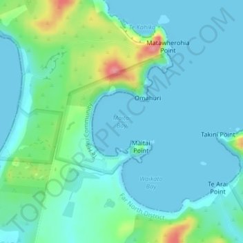
Name: Maitai Bay topographic map, elevation, terrain.
Location: Maitai Bay, Northland, New Zealand (-34.82483 173.41071 -34.82473 173.41081)
Average elevation: 18 m
Minimum elevation: 0 m
Maximum elevation: 89 m
Make a donation
Gear up for your next adventure:
As an Amazon Associate, this site earns from qualifying purchases at no extra cost to you.
Other topographic maps
Click on a map to view its topography, its elevation and its terrain.
Make a donation
Gear up for your next adventure:
As an Amazon Associate, this site earns from qualifying purchases at no extra cost to you.
Waihou River
New Zealand > Northland > Far North District > Kaikohe-Hokianga Community
Average elevation: 184 m
Make a donation
Gear up for your next adventure:
As an Amazon Associate, this site earns from qualifying purchases at no extra cost to you.
Lake Ōmāpere
New Zealand > Northland > Far North District > Kaikohe-Hokianga Community
Average elevation: 243 m
Ahiaruhe Shell Bank
New Zealand > Northland > Far North District > Te Hiku Community
Average elevation: 3 m
Make a donation
Gear up for your next adventure:
As an Amazon Associate, this site earns from qualifying purchases at no extra cost to you.
Whirinaki River
New Zealand > Northland > Far North District > Kaikohe-Hokianga Community
Average elevation: 368 m
Make a donation
Gear up for your next adventure:
As an Amazon Associate, this site earns from qualifying purchases at no extra cost to you.
Awaroa River
New Zealand > Northland > Far North District > Kaikohe-Hokianga Community
Average elevation: 101 m
Awanui River
New Zealand > Northland > Far North District
Flooding poses a threat in the lower Awanui Catchment due to the low lying topography. The risk of flooding is particularly notable in the towns of Kaitaia and Awanui. Northland Regional Council monitors the Awanui River levels, as well as planning and implementing flood protection works.
Average elevation: 21 m
Make a donation
Gear up for your next adventure:
As an Amazon Associate, this site earns from qualifying purchases at no extra cost to you.
Kerikeri River
New Zealand > Northland > Far North District > Bay of Islands > Waipapa
Average elevation: 72 m
Lake Waiparera
New Zealand > Northland > Far North District > Te Hiku Community
Average elevation: 32 m
Make a donation
Gear up for your next adventure:
As an Amazon Associate, this site earns from qualifying purchases at no extra cost to you.
Victoria River
New Zealand > Northland > Far North District > Te Hiku Community
Average elevation: 119 m
Make a donation
Gear up for your next adventure:
As an Amazon Associate, this site earns from qualifying purchases at no extra cost to you.
Hope Reef
New Zealand > Northland > Far North District > Bay of Islands-Whangaroa Community
Average elevation: 7 m
Te Tii Waitangi Marae
New Zealand > Northland > Far North District > Bay of Islands-Whangaroa Community > Paihia
Average elevation: 14 m
Make a donation
Gear up for your next adventure:
As an Amazon Associate, this site earns from qualifying purchases at no extra cost to you.
Bay of Islands-Whangaroa Community
New Zealand > Northland > Far North District
Average elevation: 91 m
Make a donation
Gear up for your next adventure:
As an Amazon Associate, this site earns from qualifying purchases at no extra cost to you.