
Custer County topographic map
Click on the map to display elevation.
About this map
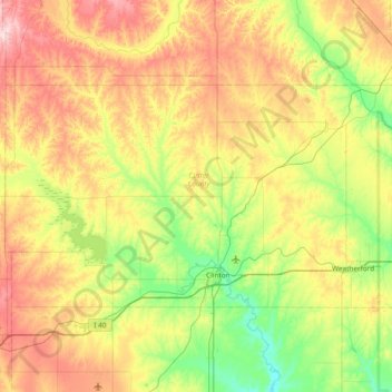
Name: Custer County topographic map, elevation, terrain.
Location: Custer County, Oklahoma, United States (35.46437 -99.37705 35.81268 -98.62320)
Average elevation: 534 m
Minimum elevation: 430 m
Maximum elevation: 697 m
Other topographic maps
Click on a map to view its topography, its elevation and its terrain.
Southwest Oklahoma City Sludge Lagoon Dam
United States > Oklahoma > Cleveland County > Oklahoma City
Average elevation: 348 m
Lake Thunderbird Dam
United States > Oklahoma > Cleveland County > Norman > Little Axe
Average elevation: 318 m