Geolocate

Vange topographic map

Click on the map to display elevation.

About this map

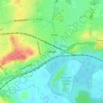
Name: Vange topographic map, elevation, terrain.

Location: Vange, Basildon, Essex, England, SS16 4TG, United Kingdom (51.54163 0.47368 51.58163 0.51368)

Average elevation: 19 m

Minimum elevation: -3 m

Maximum elevation: 66 m

Other topographic maps

Click on a map to view its topography, its elevation and its terrain.

Noak Bridge

United Kingdom > England > Essex > Basildon > Noak Hill

Average elevation: 29 m

Gloucester Park

United Kingdom > England > Essex > Basildon

Average elevation: 34 m

Gear up for your next adventure:

🥾Trekking Poles - Adjustable trekking poles to reduce knee stress and improve stability
🥾Durable Hiking Shoes - Long-lasting shoes for frequent hiking
🥾Trail Hiking Socks - Comfortable socks to prevent blisters and fatigue
👟Leg Gaiters - Keep debris, mud, and snow out of your boots
🥾Hiking Leggings - Comfortable leggings for outdoor activities

As an Amazon Associate, this site earns from qualifying purchases at no extra cost to you.