Geolocate

Sta. Ana topographic map

Click on the map to display elevation.

About this map

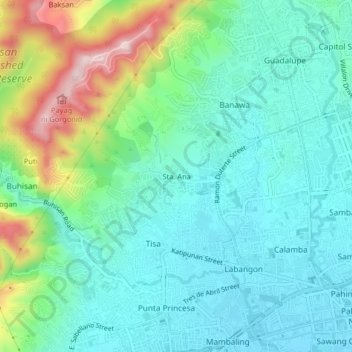
Name: Sta. Ana topographic map, elevation, terrain.

Location: Sta. Ana, Cebu City, Central Visayas, 6000, Philippines (10.28990 123.85135 10.32990 123.89135)

Average elevation: 85 m

Minimum elevation: 1 m

Maximum elevation: 327 m

Other topographic maps

Click on a map to view its topography, its elevation and its terrain.

Butuanon River

Philippines > Cebu City

Average elevation: 44 m

Fort San Pedro

Philippines > Cebu City

Average elevation: 3 m

San Roque

Philippines > Cebu City

Average elevation: 4 m

Hippodromo Park

Philippines > Cebu City

Average elevation: 13 m

Pari-an

Philippines > Cebu City

Average elevation: 8 m

TIEZA Pond

Philippines > Cebu City > Malubog

Average elevation: 471 m

Guadalupe River

Philippines > Cebu City

Average elevation: 220 m

Butuanon River

Philippines > Cebu City

Average elevation: 105 m

Kotkot River

Philippines > Cebu City

Average elevation: 316 m

SM Tower

Philippines > Cebu City

Average elevation: 3 m

Butuanon River

Philippines > Cebu City

Average elevation: 85 m

Butuanon River

Philippines > Cebu City

Average elevation: 41 m

CBP Central Park

Philippines > Cebu City

Average elevation: 19 m

Butuanon River

Philippines > Cebu City

Average elevation: 230 m

Sambag I

Philippines > Cebu City

Average elevation: 14 m

Mananga River

Philippines > Cebu City > Buot

Average elevation: 351 m

Buhisan Dam

Philippines > Cebu City > To-ong > Puti

Average elevation: 221 m

Gear up for your next adventure:

🥾Hiking Shorts - Breathable shorts suitable for summer hikes
🛏️Sleeping Bag - Warm and compact sleeping bags for outdoor camping
🚲Handlebar Phone Mount - View topographic-map.com live while cycling
🛶Kayak Dry Bag - Waterproof storage for kayaking adventures
🧊Insulated Water Bottle - Keeps drinks cold in summer and prevents freezing in winter

As an Amazon Associate, this site earns from qualifying purchases at no extra cost to you.