Snake Range topographic map
Click on the map to display elevation.
Snake Range
The Snake Range is a mountain range in White Pine County, Nevada, United States. The south-central portion of the range is included within Great Basin National Park, with most of the remainder included within the Humboldt-Toiyabe National Forest. The range reaches a maximum elevation of 13,065 feet (3,982 m) at the summit of Wheeler Peak, the tallest independent mountain within Nevada and the second highest point within the state (the highest point being Boundary Peak). The range also contains four of the five highest mountain peaks in Nevada, including all peaks greater than 12,000 feet (3,658 m) except for Boundary Peak.
About this map
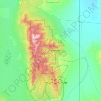
Name: Snake Range topographic map, elevation, terrain.
Location: Snake Range, White Pine County, Nevada, United States (38.69341 -114.40564 39.15549 -114.11983)
Average elevation: 1,996 m
Minimum elevation: 1,505 m
Maximum elevation: 3,927 m
Other topographic maps
Click on a map to view its topography, its elevation and its terrain.

Ruth
United States > Nevada > White Pine County
Ruth experiences a semi-arid climate (Bsk) with hot summers and cold winters, typical of most small towns in the Great Basin. Due to Ruth's substantial elevation and aridity, the diurnal temperature variation is large. Nights are cool, even in the summer, and frosts can occur any time of the year, although…
Average elevation: 2,116 m