Geolocate

Mount Tai topographic map

Click on the map to display elevation.

About this map

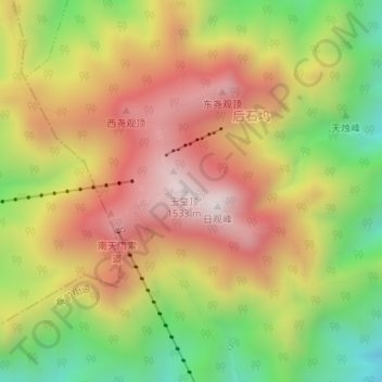
Name: Mount Tai topographic map, elevation, terrain.

Location: Mount Tai, Tai'an City, Shandong, 271000, China (36.25687 117.10313 36.25697 117.10323)

Average elevation: 1,152 m

Minimum elevation: 729 m

Maximum elevation: 1,529 m

Gear up for your next adventure:

🧦Crew Hiking Socks - Comfortable socks for long-distance hikes
💧Hydration Pack - Hands-free hydration system for long hikes
👟Sport Hiking Sandals - Breathable footwear for water crossings and camp rest
🧥Softshell Hiking Jacket - The perfect balance of wind protection and breathability
🥾Durable Hiking Shoes - Long-lasting shoes for frequent hiking

As an Amazon Associate, this site earns from qualifying purchases at no extra cost to you.