Geolocate

Broadlands topographic map

Click on the map to display elevation.

About this map
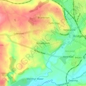
Name: Broadlands topographic map, elevation, terrain.

Location: Broadlands, Bridgend County Borough, Wales, CF31 5BJ, United Kingdom (51.48168 -3.62302 51.52168 -3.58302)

Average elevation: 43 m

Minimum elevation: 3 m

Maximum elevation: 90 m

Other topographic maps

Click on a map to view its topography, its elevation and its terrain.

Newton

United Kingdom > Wales > Bridgend County Borough > Newton

Average elevation: 22 m

Gear up for your next adventure:

🛌Down Sleeping Bag - Superior warmth-to-weight ratio for cold nights
🔦UV Flashlight - Detect minerals or specific insects in the dark
🏕️Camping Hammock - Integrated protection for sleeping between trees
🧢Beanie Hat - Keep your head warm in cold weather
🚲MTB Frame Bag - Carry tools and maps directly on your bicycle frame

As an Amazon Associate, this site earns from qualifying purchases at no extra cost to you.