Geolocate

Elida topographic map

Click on the map to display elevation.

About this map

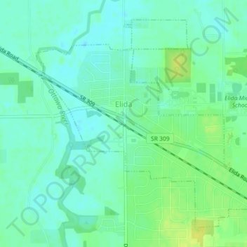
Name: Elida topographic map, elevation, terrain.

Location: Elida, Allen County, Ohio, United States (40.77515 -84.21652 40.79787 -84.18449)

Average elevation: 244 m

Minimum elevation: 237 m

Maximum elevation: 255 m

Other topographic maps

Click on a map to view its topography, its elevation and its terrain.

Lima

United States > Ohio > Allen County

Average elevation: 267 m

Gomer

United States > Ohio > Allen County

Average elevation: 237 m

Westminster

United States > Ohio > Allen County

Average elevation: 294 m

Allentown

United States > Ohio > Allen County > Lima

Average elevation: 250 m

Conant

United States > Ohio > Allen County

Average elevation: 251 m

Hume

United States > Ohio > Allen County

Average elevation: 260 m

Kemp

United States > Ohio > Allen County

Average elevation: 256 m

Landeck

United States > Ohio > Allen County

Average elevation: 242 m

Maysville

United States > Ohio > Allen County

Average elevation: 307 m

Rockport

United States > Ohio > Allen County

Average elevation: 248 m

Scotts Crossing

United States > Ohio > Allen County

Average elevation: 239 m

South Warsaw

United States > Ohio > Allen County

Average elevation: 283 m

Southworth

United States > Ohio > Allen County

Average elevation: 247 m

West Newton

United States > Ohio > Allen County

Average elevation: 316 m

Gear up for your next adventure:

🥾Lightweight Hiking Shoes - Comfortable shoes for day hikes
🥾Light Trekking Boots - Supportive boots for multi-day treks
🧢Hiking Sun Hat - Wide-brimmed protection for exposed mountain ridges
🩹Compact First Aid Kit - Pre-packed essentials for common trail injuries
🧦Outdoor Socks - Durable socks designed for hiking and outdoor sports

As an Amazon Associate, this site earns from qualifying purchases at no extra cost to you.