Geolocate

North Utica topographic map

Click on the map to display elevation.

About this map

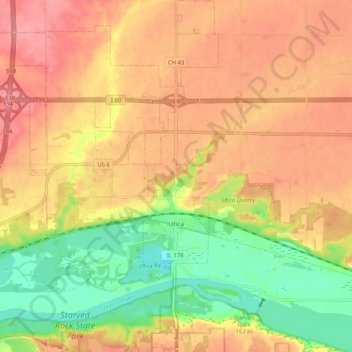
Name: North Utica topographic map, elevation, terrain.

Location: North Utica, LaSalle County, Illinois, 61373, United States (41.31217 -89.03889 41.38982 -88.99088)

Average elevation: 175 m

Minimum elevation: 126 m

Maximum elevation: 209 m

Other topographic maps

Click on a map to view its topography, its elevation and its terrain.

Wedron

United States > Illinois > LaSalle County

Average elevation: 179 m

Dayton

United States > Illinois > LaSalle County

Average elevation: 179 m

Hitt

United States > Illinois > LaSalle County > Ottawa

Average elevation: 174 m

Serena

United States > Illinois > LaSalle County

Average elevation: 192 m

Gear up for your next adventure:

🛶Waterproof Dry Bags - Keep electronics and clothes dry during river crossings
🛏️Sleeping Bag - Warm and compact sleeping bags for outdoor camping
🧼Travel Hand Sanitizer - Keep hands clean when water is scarce
🥾Light Trekking Boots - Supportive boots for multi-day treks
🌡️Emergency Mylar Blankets - Compact thermal protection for unexpected nights outdoors

As an Amazon Associate, this site earns from qualifying purchases at no extra cost to you.