Geolocate

Fawley topographic map

Click on the map to display elevation.

About this map

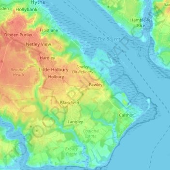
Name: Fawley topographic map, elevation, terrain.

Location: Fawley, New Forest, Hampshire, England, United Kingdom (50.78332 -1.40897 50.87062 -1.30127)

Average elevation: 13 m

Minimum elevation: -5 m

Maximum elevation: 42 m

Gear up for your next adventure:

🧰Multitool Knife - Compact and versatile tool for outdoor use
👖Convertible Hiking Pants - Zip-off legs to adapt to changing weather conditions
🧥Fleece Jacket - Warm and lightweight jacket for layering
🛌Down Sleeping Bag - Superior warmth-to-weight ratio for cold nights
🧥Waterproof Pants - Keep dry during rainy hiking conditions

As an Amazon Associate, this site earns from qualifying purchases at no extra cost to you.